Petroform Astronomy“Arise to greet the morning star!” traditional Dakota crier call A Fascinating PuzzleA fascinating puzzle faces anyone today who looks at the many stones, stone piles and intact petroforms of southwestern Manitoba. How were they used? In 1977 astronomer Dr. John Eddy concluded that most of the “medicine wheels” and “petroforms” of the Great Plains and Canadian Prairies include sighting markers for making astronomical observations. These findings were published in Scientific American and National Geographic, creating a modest stir at the time. Since then the work has been taken up by some Native people themselves, but has not received as much serious attention from the rest of the scientific community. Few archaeologists incorporate Eddy’s ideas into their analysis of stone formations. On Turtle Mountain oral history tells us that Native elders and medicine people used natural landforms to mark the seasons. Literally hundreds of stone forms and mud mounds dot the landscape in and around Turtle Mountain, and even the hills themselves are incorporated into the patterns. Eddy (and his few successors) found that there were seven key markers that were almost always present — regardless of whether the site was a wheel, an effigy or an arrangement of mounds. The markers themselves could be stones, stakes or pieces of landscape. The chart shown below left is based on the medicine wheel atop Moose Mountain, SK. Markers A, B, C, and D are “front sights” for observing the positions of Aldebaran, Rigel, Sirius and Fomalhaut on specific days of the year. Markers E and F are “back sights” through which observations are made of the other stones. The last marker, O, is near the centre of the structure. Observing from E through O gives the summer solstice sunrise. Aldebaran, Rigel and Sirius gave “morning star” positions for one, two and three months after the summer solstice. The Fomalhaut sight gave a date approximately one month before the winter solstice. Eddy concentrated on morning and summertime observations. It is probable that the sites were also used for winter and evening observations as well. Unfortunately much of this knowledge has been lost. Most of these angles stay relatively constant, but Aldebaran’s position relative to earth has gradually shifted it counterclockwise until it no longer rises as a morning star. Some astronomers believe that approximate dates can be determined for the last use of a medicine wheel by measuring the angle of the Aldebaran sight and comparing it to tables. The oldest site determined so far, at Moose Mountain, has been radiocarbon dated to approximately 500 BC. Most of these sites have been disturbed and it may never be possible to determine where stones or markers originally lay. However, an historical accident resulted in one “hidden” site on Turtle Mountain being surveyed. A Tale of Two Astronomical Instruments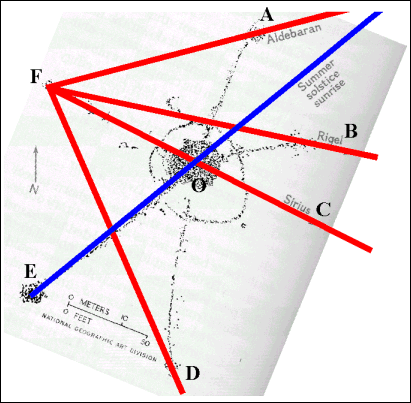 The diagram above is an astronomer’s analysis of the angles on sighting stones found at Moose Mountain, Saskatchewan. The diagram below is based on the 1909 Dominion Land Survey of the Turtle Mountain Dakota reserve. The lines were drawn over the Moose Mountain diagram, and then superimposed on the No. 60 Reserve survey indicating possible relationships. The apparently haphazard placement of the plots probably points to other sight lines. 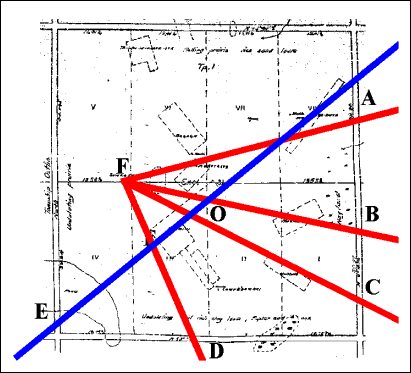 < Development Stages of TM | Contents | Principles of Archaeoastronomy > |
Copyright © 2002 Moncur Gallery. All Rights Reserved. Republished with permission.
This is document available from: http://turtlemountain.org/exhibits/mythandhistory/astronomy